


Mapa Turystyczna

Description of Mapa Turystyczna
পর্যটন মানচিত্র হল একটি অ্যাপ্লিকেশন যা পর্বত ভ্রমণের পরিকল্পনার সুবিধার্থে এবং রুটে নেভিগেশনে সাহায্য করার জন্য তৈরি করা হয়েছে।
রুট পরিকল্পনা
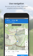
প্রধান ফাংশন হল পর্বত এবং পাদদেশে হাইকিং ট্রেল বরাবর রুট পরিকল্পনা করার ক্ষমতা। অ্যাপ্লিকেশনটি সহজে এবং দ্রুত রুট গণনা করে, মানচিত্রে এর কোর্স প্রদর্শন করে, এর দৈর্ঘ্য এবং উত্তরণের আনুমানিক সময়, বিস্তারিত রুট এবং উচ্চতা প্রোফাইল দেখায়। এটি ব্যবহারকারীর বর্তমান অবস্থানও নির্দেশ করে।
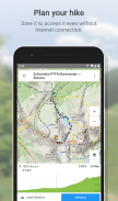
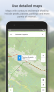
একটি বিশদ পর্যটন মানচিত্র, কনট্যুর লাইন এবং ভূখণ্ডের শেডিং ছাড়াও, চূড়া, পাস, পার্কিং লট এবং অন্যান্য ল্যান্ডমার্ক অন্তর্ভুক্ত করে। প্রিমিয়াম সংস্করণে, আপনি নীচে তালিকাভুক্ত অঞ্চলগুলির মানচিত্র ডাউনলোড করতে পারেন এবং সেগুলি অফলাইনে ব্যবহার করতে পারেন৷
রুট রেকর্ডিং
দ্বিতীয় গুরুত্বপূর্ণ বৈশিষ্ট্য হল রুট রেকর্ড করার ক্ষমতা। মানচিত্রে রুটের কোর্স, এর দৈর্ঘ্য এবং সময়কাল সংরক্ষণ করা হয়েছে।
ওয়েবসাইটের সাথে রুটের সিঙ্ক্রোনাইজেশন
পরিকল্পিত রুট এবং রেকর্ড করা ভ্রমণ উভয়ই ব্যবহারকারীর অ্যাকাউন্টে সংরক্ষণ করা হয়। সিঙ্ক্রোনাইজেশনের জন্য ধন্যবাদ, এগুলি mapa-turystyczna.pl ওয়েবসাইটেও পাওয়া যায়, যেখানে আপনি সুবিধামত বিস্তারিত পরামিতি দেখতে পারেন।
আকর্ষণীয় স্থান
এছাড়াও, অ্যাপ্লিকেশনটি আকর্ষণীয় স্থান সম্পর্কে তথ্য প্রদর্শন করে: mapa-turystyczna.pl ওয়েবসাইট থেকে ডেটার উপর ভিত্তি করে ফটো এবং ব্যবহারকারীর পর্যালোচনা।
বিস্তারিত ফাংশন:
- প্রদত্ত পয়েন্টের উপর ভিত্তি করে রুট অনুসন্ধান; পয়েন্টগুলি মানচিত্র থেকে নির্বাচন করা যেতে পারে বা অনুসন্ধান ইঞ্জিনে পাওয়া যেতে পারে,
- বর্তমান অবস্থানের নিকটতম স্থান এবং সর্বাধিক জনপ্রিয় স্থান বিবেচনা করে স্থান সন্ধানকারীতে বুদ্ধিমান ইঙ্গিত,
- মানচিত্রে অনুসন্ধান করা রুট প্রদর্শন করা এবং এর দৈর্ঘ্য, যাতায়াতের আনুমানিক সময়, বিস্তারিত রুট (রুটে স্থান এবং পৃথক ট্রেইল) এবং উচ্চতা প্রোফাইল,
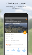
- পথের উপর বাধা সম্পর্কে বার্তা,
- পাওয়া রুটের জন্য স্কোর পেয়েছি,
- মানচিত্রে বর্তমান অবস্থান দেখাচ্ছে,
- কম্পাস,
- রুট রেকর্ডিং; যাত্রার দূরত্ব এবং শুরু থেকে অতিবাহিত সময় একটি চলমান ভিত্তিতে দেখানো হয়,
- রেকর্ড করা রুটের তালিকা,
- স্থানগুলি অনুসন্ধান করা এবং সেগুলি মানচিত্রে দেখানো,
- পাওয়া স্থানগুলি সম্পর্কে তথ্য প্রদর্শন করা হচ্ছে: mapa-turystyczna.pl ওয়েবসাইট থেকে ডেটার উপর ভিত্তি করে ফটো এবং ব্যবহারকারীর পর্যালোচনা,
- অনুসন্ধান করা রুটে নেভিগেশন,
- বিস্তারিত পর্যটন মানচিত্রের একটি স্তর, ডাউনলোড এবং অফলাইন ব্যবহারের জন্যও উপলব্ধ।
পথের নেটওয়ার্কের মধ্যে রয়েছে যেমন অঞ্চল:
* বেস্কিডস
** মাকোস্কি বেস্কিডস
** ছোট বেস্কিডস
** কম বেস্কিড
** Beskid Sądecki
** সাইলেসিয়ান বেস্কিডস
** সাইলেসিয়ান-মোরাভিয়ান বেস্কিড
** বেস্কিড উইসপোওয়াই
** বেস্কিড Żywiecki
** Bieszczady
** গরম
* সুডেটস
** বারডজকি পর্বতমালা
** Bystrzyckie পর্বতমালা
** ঈগল পর্বত
** জিজেরা পর্বত
** Kaczawskie পর্বতমালা
** পাথরের পাহাড়
** ওপাভা পর্বতমালা
** পেঁচা পর্বত
** টেবিল পর্বত
** ওয়ালব্রজিচ পর্বতমালা
** সোনার পাহাড়
** সাদা পাহাড়
** দৈত্যাকার পর্বত
** জেলেনিওগোরস্কা উপত্যকা
** Śnieżnik ম্যাসিফ
** রুদাউই জানোভিকি
* সুডেটদের পাদদেশ
** ইজারস্কি ফুটহিলস
** Kaczawskie Foothills
* সুডেকি ফুটহিলস
** Ślęża ম্যাসিফ
** Paczkowskie এর পাদদেশ
** সুইডনিকা সমভূমি
** Niemczańsko-Strzelińskie পাহাড়
** স্ট্রজেগম পাহাড়
* বেস্কিডের পাদদেশ
** Ciężkowickie ফুটহিলস
** প্রজেমিশল পাদদেশ
** Rożnów পাদদেশ
** Strzyżow Foothills
** ডাইনো পাদদেশ
** উইলিক্সকা ফুটহিলস
** উইশনিকি ফুটহিলস
* অবশিষ্ট
**উলিন দ্বীপ
** Swietokrzyskie পর্বতমালা
** সুচেডনিওস্কি মালভূমি
** কাম্পিনোস বন
** জুরা ক্রাকওস্কো-চেস্টোচোস্কা
** ক্র্যাকো গেট
** পাইনিনি
** তাত্রা পর্বতের পাদদেশ
** ওরাভা বিভাগ
** তত্রা পর্বত
* স্লোভাকিয়া
** চোচ পর্বতমালা
** স্কোরুসজিনস্কি উইয়েরচি
** কিসুকি পর্বতমালা
** মাগুরা ওরওস্কা
** স্পিস মাগুরা
** সামান্য ফাতরা
** কম টাট্রাস
** স্লোভাক স্বর্গ
** মহান ফাতরা
** উচ্চ Tatras
অ্যাপটি বিনামূল্যে। রুট পরিকল্পনা করতে এবং স্থান সম্পর্কে তথ্য দেখতে আপনাকে অবশ্যই ইন্টারনেটের সাথে সংযুক্ত থাকতে হবে। ট্যুরিস্ট ম্যাপ ডাউনলোড এবং নেভিগেশন প্রিমিয়াম (প্রদেয়) বিকল্পে উপলব্ধ।
Mapa Turystyczna - Version 1.13.9
(20-11-2024)
Mapa Turystyczna - APK Information
APK Version: 1.13.9Package: pl.mapa_turystyczna.appLatest Version of Mapa Turystyczna
Other versions


Apps in the same category

You may also like...


